Originally published as the center spread feature in The Western Front weekly student newspaper.
THE WESTERN FRONT November 14, 2018
By Brooke Wilson
Surrounded by the grand landscapes of the Pacific Northwest, even a native resident could be fooled by such an idyllic scene. For the Whatcom County community, what lies brewing beneath the surface has the potential to pose a large-scale environmental disaster.
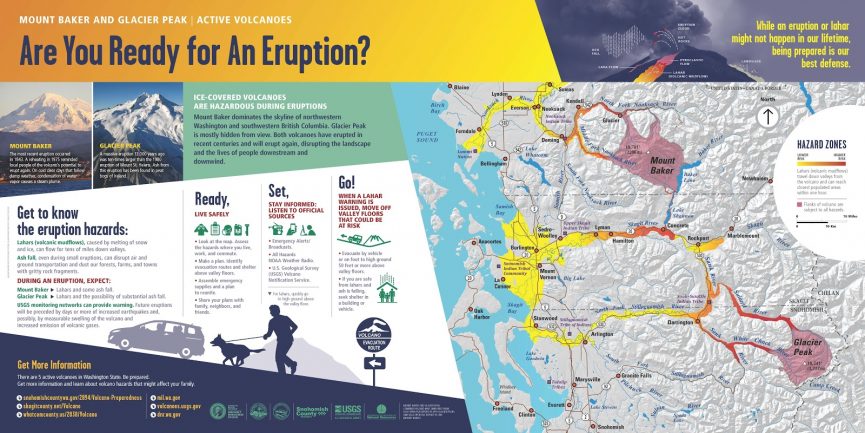
Eighteen volcanoes in the U.S., including Mount Baker in Bellingham’s backyard, have been classified by a recent United States Geological Survey as a “very high threat.”
States along the West Coast have 11 of the 18 volcanoes filed under the highest threat level category by a five-tiered ranking system. Volcanoes are sorted based on criteria that gauge activity, from those that require relatively low surveillance to others that indicate cause for alarm, according to the USGS.
At first glance, the recent report could seem like reason enough to pack your bags and flee Whatcom County. Geologist Elizabeth Westby from the Cascades Volcano Observatory argues otherwise.
“The assessment isn’t a list of which volcanoes are most likely to erupt, nor does it rank the most active volcanoes,” Westby said. “Instead, the assessment merely quantifies the relative threat posed by volcanoes in the United States.”
Westby also clarified that the threat classification does not intend to instill fear, but rather offer geologists a clear understanding of which volcanoes should be closely monitored and specific areas that need more support in prepping for a potentially destructive volcanic eruption.
Comprehensive threat scores are assigned to the 161 young, active volcanoes in the U.S. through a combination of factors. Associate professor of geology at Western, Pete Stelling, said geologists look at volcanic type, hazardous potential, recent activity, how often eruptions occur and the possibility of air traffic disruption. They also take into account any indications of seismic activity, the number of people an eruption could affect and history of past evacuations.
Western geology professor Jackie Caplan-Auerbach said there are several reasons why Mount Baker raises eyebrows within the scientific community.
While the likelihood of a violent explosion remains low, Caplan-Auerbach noted that its close proximity to communities in western Whatcom County during its active years, poses a significant danger to residents nearby.
“Knowing when a volcano is acting up requires first knowing its normal behavior, which means we should be collecting background data now in order to identify changes, if any occur,” Caplan-Auerbach said.
For instance, Mount Baker only has two seismometers, devices that monitor volcanic activity and are the first line of defense in the event of an eruption, Caplan-Auerbach explained. Her voice, along with the staff at the Cascades Volcano Observatory, are raised in advocating for more measures to gather a larger data sample on the mountain, despite the challenges in deploying these instruments within a wilderness region like Mount Baker.
Whether given 24-hours notice or several months, Stelling said the ultimate problem lies in trying to calculate the time frame an eruption could occur, since no one actually can.
“Trying to predict an eruption is like trying to predict when you might catch an illness,” Stelling said. “Instead, people focus on trying to assess symptoms as quickly as possible and take appropriate action based on those observations.”
One method to interpret warning signs, Caplan-Auerbach pointed out, aims at identifying an increase in seismic activity that precedes most eruptions. In other words, a greater number of small earthquakes and changes in magnitude detected beneath the mountain can signal a looming geologic event.
Stelling added that other symptoms worth keeping an eye on include slight inflation or swelling within the mountain. Gas emissions and an increase in surface temperature near Mount Baker are also cues that something severe could be afoot. And since these developments cannot be detected by the naked eye, satellites and other instruments are employed to collect the data.
The last notable eruption occurred approximately 6,750 years ago, according to Caplan-Auerbach, adding that the majority of recent eruptions at Mount Baker have been comparatively small. In the future, she predicts eruptions will also be minor and manageable.
“In the past, [Mount Baker] has had enormous lahars, or volcanic mudslides, that have flowed down the Nooksack and Skagit rivers. Since local populations are concentrated around the rivers, this has the potential to be a damaging situation,” Caplan-Auerbach said.
For a small eruption, Caplan-Auerbach said the collateral damage should be relatively contained to the mountain itself, although could still affect recreation and pose grave impacts to the nearby ski resort. However, the potential for eruptive material or landslides to enter nearby Baker Lake still exists, which could lead to dam failure. Downstream communities along the Skagit River could experience flooding and mudflows; even a considerably small eruption could generate glacial melt, Caplan-Auerbach said.
Volcanic emergencies aside, landslides and lahars could occur even without a violent eruption due to melting glaciers and seismic activity. Caplan-Auerbach said the geologic evidence in surrounding sediment patterns and landforms indicates that lahars have previously flowed into the Sumas River, located just north of the border in British Columbia, Canada.

If a volcanic mudflow proved substantial enough, Caplan-Auerbach anticipates that sediment and other debris collected over time could ooze into Bellingham Bay and even extend toward Canada. Additionally, volcanic mudflow could migrate out of stream channels and destroy urban infrastructure, devastate communities and mire agriculture.
Nearly $8 billion worth of private, agricultural, commercial, natural and government resources could be at risk from lahars and ashfall, according to estimates from the Division of Emergency Management in Whatcom County.
For folks living in western Whatcom County or students at Western, Caplan-Auerbach said the only volcanic hazard that might reach campus would be ash from a large eruption, and that would only be the case if the winds blew in an unusual direction. Typically, regional wind patterns travel eastbound, and in that case, ash particles would be carried away from Bellingham city limits.
Thankfully, the brightest minds in the local community and across national borders have joined forces to plan for necessary recourse through a worst-case scenario simulation.
On Oct. 16., an eruption exercise at the Whatcom Unified Emergency Operations Center brought government agencies and organizations together throughout the week to orchestrate a timely natural disaster response.
From shelter preparations by search-and-rescue teams to hospital protocol for patients affected by volcanic mudflow or ash inhalation, each division rehearsed their respective duties to ensure that all possible outcomes were thought through in case of an emergency.
On behalf of the USGS team, Elizabeth Westby, who attended the training exercise, said that the event aims to build relationships and establish a network of support to handle a natural disaster and the challenges that follow.
